Font Froide Mountain Pass
« One morning in July, leaving the forest, a cold wind came down from the rocky glacier at Font Froide. That is also where the glacial water from the source called Font (fountain) comes from... Decidedly, this mountain pass suits its name. But rapidly, the ascent warms the muscles and the whole body. The mountain pass is in view when a high pitched whistle makes me jump; it is a magnificent male ibex that moves away quietly two paces away from us ».
Dominique Vincent, park ranger, during an ibex count.
Description
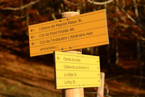
Go right up to the hamlet at Molines, and take the direction of Peyron Roux valley. The path runs beside the torrent which descends close to the village. Take the walkway to go up to the left bank of the torrent. Leave the path further up and go left. The path with a stone wall passes through the middle of a larch forest. Continue in the same direction, until you leave the forest. There the path crosses to the right bank of the valley but the torrent which descends disappears under the rock... A little later, the itinerary goes back under the undergrowth and arrives at the Peyron Roux cabin... Continue in the forest; leave the path on the left the mountain pass path the 'Ardouère, (itinerary not maintained). The path leaves the forest, meanders in the scree (after a big storm, this part can be damaged) and goes winding upwards on a steep grassy slope. An hour’s ascent is still necessary in order to reach the bottom of the rocky glacier that we go round by the right bank. It is only when the terrain becomes smoother that we notice the mountain pass... The return is made using the same itinerary until the Peyron-Roux cabin, then fork to the right to descend by the path on the right bank until Molines.
- Departure : Molines-en-Champsaur
- Arrival : Molines-en-Champsaur
- Towns crossed : La Motte-en-Champsaur
Forecast
Altimetric profile
Recommandations
The ibex do not mind being approached but it is better to observe them from further away in order to get the best view and to leave them calmly building up their reserves of fat which are indispensable for them to be able to winter.

Information desks

Valgaudemar Park house
Ancien Asile Saint-Paul, 05800 La Chapelle-en-Valgaudemar
Transport
Between Gap and La Motte-en-Champsaur, there is a possible connection with the Gap-Grenoble coach.
Access and parking
At La Fare en Champsaur (N 85), take the direction Saint-Bonnet then the direction La Motte (D23). Cross La Motte and continue until the hamlet of Molines.
Parking :
Accessibility
- Accessibility level :
- Experimented
- Emergency number :
- 114
More information
Source

Report a problem or an error
If you have found an error on this page or if you have noticed any problems during your hike, please report them to us here: